A journal recording my ongoing photographic project, Fenland.
The first day is in name only, as it’s been in the planning all week. I’ve decided to take a more controlled approach to this project instead of my usual photography strategy of “walk a route and take pictures along the way”.
I planned it because The Fens poses some unique challenges – the first being access. The land is laid out on a grid system – because it’s farmland – and requires a car for safe travel. The roads are fast and poorly maintained, and there’s almost no parking and few laybys. On foot, rights of way are few and far between – small verges are the only way to walk off the main roads. Where rights of way exist, they typically follow a significant drainage dike for miles or have been long forgotten, neglected and absorbed into gardens and farmland. Hikers paradise, this is not.
The second challenge is that, as farmland, The Fens is nearly featureless. This means that, for my preferred style of photography, I need to travel between villages, hamlets and river junctions to find subjects. Travelling between these points can take 15 minutes to 45 minutes, requiring lots of backtracking to major roads and waiting at train crossings.
Due to these two challenges, I knew that just winging a trip into The Fens wouldn’t work. So, using a combination of local knowledge and Google Maps Streetview, I had a handful of spots scouted ahead of time, complete with spots I knew I could pull over.
Pondersbridge
Pondersbridge was my first location – a small village with street parking split over Bevill’s Leam, a large river-sized drainage dike.
I had some ideas about what I wanted for the Fenland Project. Namely, black and white landscape shots that could be cropped to 16:9 to accentuate the flatness. However, Pondersbrige quickly introduced a problem I hadn’t considered until I was on location: The Fens are really flat, and because of this, any features in the foreground block everything else, and there’s no way to get any height.
This compositionally led to some exciting challenges, and I don’t think I managed to get a good shot out of my 40-some-minutes in the village. I tried to use the extra height of Ponder’s Bridge – zero points for guessing the village name’s etymology – but nothing was singing to me. A little stroll down a road and a perch on a verge gave me some angles on a distant wind farm. There’s something there, but I didn’t find it today. I will return with my 100-400mm zoom to explore the wind farm further, possibly with some long exposures.
I did get a couple of interesting rural ‘mundane’ shots of two houses, so there’s some silver lining there.
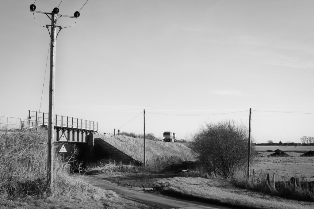
Beggar’s Bridge

A short distance from Pondersbridge, the Bevill’s Leam merges with Whittlesey Dike and becomes Twenty Foot River. Over this river-slash-drain is Beggar’s Bridge. Getting there was a 20-minute drive, which took me through Whittlesey. I noticed a few potential spots as I passed, so I’ll return with my 35mm prime setup.
Beggar’s Bridge was a more enjoyable spot, as a road, train track and dike all interact in novel ways. Plus, the banks of Bevill’s Leam are very high and broad, giving me some extra compositional depth to work with.
I practised patience here and decided to work the scenes available – ironic, given that the bank is a fishing spot. I spent an hour within a 100m radius, carefully ensuring that my frame was balanced, that objects weren’t competing and that elements had room to breathe.
Whatever the quality of the images here, I enjoyed the challenge, and I am starting to feel that these compositional moments will become a defining feature of the project. In the past, I’ve tended to be a bit frantic with my shooting and annoyed that I’m not getting more shots. This also served as a welcome reminder to slow down, think and be present.
Eastrea
A diversion from my original plan saw me return to Eastrea, just outside Whittlesey. I wanted to shoot some colour I’d spotted as I drove through. Again, I kept myself in check and worked the scenes, paying particular attention to element balance and colour.
The only downside here was that I started to fall out with my lens – Fuji XF 16-55mm – and began to wish I’d just brought my 35mm equivalent prime.
French Drove
It was getting late, but my last stop was French Drove and a nearby derelict house. My plans were scuppered as flooding had closed some roads. So, I turned around – another day will come.
Key takeaways
Here’s what I’ve taken away from today:
- Planning pays off, and I should do it before more trips.
- But I should keep the plan fluid, allowing my instincts on the day to switch as needed.
- A new day will come, so there is no need to stress over not hitting every planned spot. I had six locations scouted and only made two. And that’s okay.
- Slowing down yields results, and that manic and frantic “I need to get X amount of pictures” mindset is unhelpful. Calm photography is satisfying.
- I’ve never taken a photograph with the XF 16-55mm that I couldn’t have done just as well or better with a prime. It’s now in the post, traded in.
Subscribe to my blog for updates, and thanks for reading.

Leave a reply to Fenland: Update. April 7th, 2024. – William Austin-Lobley Photography Cancel reply